Reading Volcanic Landscapes in Tongariro National Park
Tongariro National Park, located in the central North Island of New Zealand, is a dynamic volcanic environment that offers a remarkable record of past eruptions. The park encompasses a complex of volcanic cones, craters, and extensive lava fields that have been shaped by both effusive and explosive activity over thousands of years. For those traversing the Tongariro Alpine Crossing, the landscape provides a natural laboratory for interpreting volcanic processes and understanding the sequence of events that built this rugged terrain. Reading these volcanic features requires careful observation and an appreciation of the geological forces at work.
The Tongariro Alpine Crossing is a popular day hike that passes through a variety of volcanic landforms, each telling a part of the story. From solidified lava flows to layered ash deposits and distinct craters, the route exposes the products of different eruption styles and magnitudes. By examining the characteristics of these materials—their texture, colour, and arrangement—visitors can begin to reconstruct the volcanic history of the area. This article explores how these features can be interpreted and what they reveal about the eruptive past of Tongariro National Park.
Understanding volcanic landscapes is not only of scientific interest but also contributes to a deeper appreciation of the dynamic nature of the Earth’s crust. The features along the crossing are the result of numerous eruptions, each leaving its mark on the terrain. By learning to read these signs, hikers and enthusiasts can gain insights into the processes that continue to shape this unique environment. The following sections will delve into the specifics of lava flows, ash layers, and craters, and how they can be deciphered to uncover the eruption history.
Interpreting Lava Flows and Their Morphology
Lava flows are among the most conspicuous volcanic features in Tongariro National Park. They form when molten rock reaches the surface and spreads laterally, solidifying as it cools. The morphology of a lava flow—its thickness, extent, and surface texture—provides clues about the eruption’s characteristics, such as the viscosity of the magma and the rate of effusion. For example, flows with a smooth, ropy surface, known as pahoehoe, typically indicate low-viscosity lava that travelled relatively quickly. In contrast, flows with a rough, blocky surface, called a’a, suggest higher viscosity and slower movement, often accompanied by more explosive activity.
Along the Tongariro Alpine Crossing, hikers can observe several lava flows that have been exposed by erosion or later volcanic events. These flows often appear as distinct bands or ledges in the landscape, sometimes forming prominent cliffs or ridges. By examining the orientation and relationship of these flows to surrounding deposits, one can infer the sequence of eruptions. For instance, a lava flow that overlies a layer of ash must have been emplaced after that ash was deposited. Such superposition principles allow geologists to establish relative ages and build a timeline of volcanic activity.
Moreover, the composition of lava flows can be deduced from their colour and mineral content. Dark, fine-grained rocks often indicate basaltic lava, which is typically associated with effusive eruptions and relatively low gas content. Lighter, more silica-rich rocks, such as andesite or rhyolite, may point to more viscous magmas and potentially explosive eruptions. In Tongariro, the predominant lavas are andesitic, reflecting the subduction zone setting that generates intermediate magmas. Recognising these distinctions can help in interpreting the broader eruptive style of the volcano.
- Pahoehoe lava flows: smooth, ropy surfaces indicating low viscosity and rapid flow.
- A’a lava flows: rough, blocky surfaces indicating higher viscosity and slower movement.
- Andesitic lava flows: typically associated with stratovolcanoes and explosive activity.
When observing lava flows, it is important to consider the effects of weathering and erosion, which can alter their original appearance. Over time, exposure to the elements can break down the rock, obscuring primary features. Therefore, interpretations should be based on multiple lines of evidence and an understanding of post-eruption processes. The lava flows in Tongariro National Park offer a fascinating window into the effusive history of the volcano, and careful study can reveal much about the conditions during eruption.
Reading Ash Layers and Tephra Deposits
Ash layers, also known as tephra deposits, are among the most informative volcanic features for reconstructing eruption history. These layers form when explosive eruptions eject fragmented rock, glass, and minerals into the atmosphere, which then settle to the ground. Over time, successive eruptions deposit distinct layers, creating a stratigraphic record that can be read like the pages of a book. In Tongariro National Park, ash layers are exposed along the Tongariro Alpine Crossing, particularly in cuttings and eroded gullies, where they appear as bands of varying colour, thickness, and grain size.
The characteristics of an ash layer can indicate the nature of the eruption that produced it. For instance, a thick, coarse-grained layer with abundant pumice suggests a highly explosive eruption with a high eruption column, whereas a thin, fine-grained layer may result from a smaller, less energetic event or from ash that travelled a long distance from the vent. The colour of the ash can also provide clues about its composition: dark ash often contains basaltic material, while lighter ash may be more silicic. By examining these attributes, geologists can infer the size, style, and frequency of past eruptions.
Furthermore, the sequence of ash layers can be used to correlate events across different locations. If a distinctive layer is found at multiple sites, it likely originated from a single eruption and can serve as a marker horizon. This allows for the construction of a regional tephrochronology, which is a timeline of eruptions based on ash deposits. In Tongariro, such studies have identified numerous eruptions from the various vents, including those from Mount Tongariro, Mount Ngauruhoe, and Mount Ruapehu. Each layer represents a moment in time when ash blanketed the landscape.
“The ash layers are like pages in a history book, each one recording a different eruption and its characteristics.”
Interpreting ash layers requires attention to detail and an understanding of how tephra is deposited. Factors such as wind direction, eruption column height, and subsequent reworking by water or wind can influence the distribution and appearance of ash. Therefore, it is essential to consider the broader geological context and to use multiple exposures to build a reliable picture. The ash layers along the Tongariro Alpine Crossing provide a tangible record of the explosive past of the volcano, and they continue to be a focus of geological research.
Recognising Craters and Their Significance
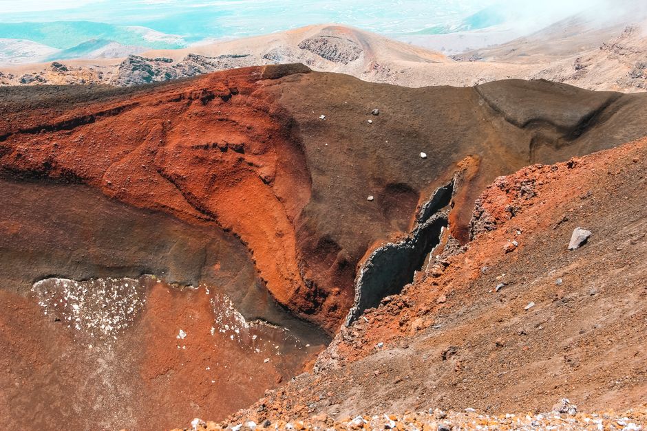
Craters are prominent volcanic features that mark the sites of past eruptions. They can form in various ways, including explosive eruptions that excavate a bowl-shaped depression, or by collapse following the withdrawal of magma. In Tongariro National Park, craters are scattered across the landscape, some filled with water to form lakes, others dry and eroded. Along the Tongariro Alpine Crossing, hikers can encounter several craters, such as the Red Crater and the Emerald Lakes, which are actually crater lakes. These features offer direct evidence of the explosive events that have shaped the area.
The size, shape, and state of preservation of a crater can provide information about the eruption that created it. A large, well-preserved crater with steep walls typically indicates a relatively recent and powerful explosion. In contrast, a shallow, eroded crater may be older and have been modified by subsequent volcanic activity or erosion. The presence of volcanic bombs and other ejecta around a crater can also indicate the direction and intensity of the eruption. For example, the Red Crater is known for its striking red colour, caused by oxidation of iron in the scoria and ash, and it is a testament to the high temperatures and explosive nature of the eruption that formed it.
Moreover, craters often serve as vents for subsequent eruptions, and their alignment can reveal the structure of the underlying magma plumbing system. In Tongariro, the craters are aligned along a northeast-southwest trend, reflecting the regional tectonic setting and the path of magma ascent. By mapping the distribution and orientation of craters, geologists can infer the stresses in the crust and the likely locations of future activity. This information is valuable for hazard assessment and for understanding the volcano’s behaviour.
Visitors to the Tongariro Alpine Crossing should observe craters from safe vantage points and avoid entering them, as they may still be geothermally active or unstable. The craters are not just scenic attractions; they are key evidence for interpreting the eruption history. Each crater tells a story of a past explosion, and together they paint a picture of a dynamic and ever-changing volcanic landscape.
Integrating Observations for a Holistic Understanding
Reading volcanic landscapes requires integrating observations from lava flows, ash layers, and craters to build a coherent narrative of eruption history. No single feature can provide a complete picture; instead, it is the combination of evidence that allows for robust interpretations. For example, a lava flow may be dated by the ash layer it overlies or is overlain by, while a crater may be the source of a particular ash deposit. By cross-referencing these features, geologists can reconstruct the sequence of events and the style of eruptions that have occurred over time.
In Tongariro National Park, the interplay between effusive and explosive activity is evident. The volcano has produced both lava flows and significant ash deposits, indicating alternating periods of quiet effusion and violent explosions. This variability is typical of stratovolcanoes, which are built up by multiple eruptions of varying magnitude. The landscape along the Tongariro Alpine Crossing is a mosaic of these products, and each segment of the trail offers a different perspective on the volcano’s past.
For those interested in learning more, guided tours with knowledgeable operators can enhance the experience by providing expert interpretation. Kiwi Wild, a company specializing in outdoor adventures, may offer such tours, allowing participants to gain deeper insights into the geological features. However, independent hikers can also develop their observational skills by studying the landscape carefully and consulting geological guides or maps. The key is to approach the landscape with curiosity and a willingness to observe details.
It is important to note that volcanic landscapes are complex and interpretations are always provisional, subject to revision as new data emerge. The features we see today are the result of numerous processes, and our understanding continues to evolve. Therefore, reading the volcanic landscape is an ongoing process of discovery, and each visit may reveal new insights. By fostering a respectful and inquisitive attitude, visitors can appreciate the remarkable geological heritage of Tongariro National Park.
Practical Considerations for Observing Volcanic Features
When exploring the Tongariro Alpine Crossing, there are several practical considerations to keep in mind. First, safety should always be a priority. Volcanic terrain can be hazardous, with steep slopes, loose rocks, and potentially active geothermal areas. Hikers should stay on marked trails, heed any warnings, and be prepared for changing weather conditions. The alpine environment can be unpredictable, and proper clothing, footwear, and supplies are essential.
Second, respecting the cultural and spiritual significance of the area is important. Tongariro National Park is a UNESCO World Heritage site and holds deep cultural value for Māori, the indigenous people of New Zealand. Visitors should be aware of and respect any cultural protocols, such as not touching or removing rocks or other natural features. The park is a taonga (treasure) and should be treated with care.
Third, to fully appreciate the volcanic features, it helps to carry a geological guide or map that identifies key points of interest. Several publications and online resources provide detailed descriptions of the geology along the crossing. Additionally, joining a guided group can offer valuable interpretation and ensure that you don’t miss important features. Whether alone or with a guide, taking the time to observe and reflect on the landscape can greatly enhance the experience.
Finally, consider the impact of your visit on the environment. Stay on the trail, pack out all rubbish, and avoid disturbing wildlife or vegetation. The volcanic landscape is fragile and takes a long time to recover from damage. By following Leave No Trace principles, you can help preserve this unique area for future generations.
In conclusion, the volcanic landscapes of Tongariro National Park offer a fascinating record of eruption history. By learning to read lava flows, ash layers, and craters, visitors can gain a deeper understanding of the dynamic processes that have shaped this land. The Tongariro Alpine Crossing provides an accessible route through this remarkable terrain, and with careful observation and respect, it can be a truly enriching experience.